![](/images/other/stat-length.png)
![Randonnée Marche Les Planches-en-Montagne - Les planches en Montagne - Saine et langouette - Photo](https://media.geolcdn.com/t/1900/400/ext.pjpeg?maxdim=2&url=https%3A%2F%2Fstatic1.geolcdn.com%2Fsiteimages%2Fupload%2Ffiles%2F1553511878bg_sport_marche.png)
Les planches en Montagne - Saine et langouette
marcel.F
Utilisateur
![Longueur](/images/other/stat-length.png)
![Altitude max](https://static1.geolcdn.com/siteimages/upload/files/1508320355ic_sort_altitude_max_24dp.png)
![Dénivelé positif](https://static1.geolcdn.com/siteimages/upload/files/1508320355ic_sort_den_pos_24dp.png)
![Km-Effort](/images/other/stat-length.png)
![Altitude min](https://static1.geolcdn.com/siteimages/upload/files/1508320355ic_sort_altitude_min_24dp.png)
![Dénivelé négatif](https://static1.geolcdn.com/siteimages/upload/files/1508320355ic_sort_den_neg_24dp.png)
![Boucle](https://static1.geolcdn.com/siteimages/upload/files/16400158638029165_repeat_loop_refresh_sync_direction_icon.png)
![Marche](https://static1.geolcdn.com/sitytour/trail-icons/101.png)
3h02
Difficulté : Moyen
![Scannez ce code QR pour ouvrir la randonnée dans l'application SityTrail](https://capi.geolives.com/qq0zvz2zws4bq2lad0pu/sitytour/trails/160382/qr.png?size=200)
Application GPS de randonnée GRATUITE
À propos
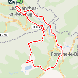
Randonnée Marche de 10,1 km à découvrir à Bourgogne-Franche-Comté, Jura, Les Planches-en-Montagne. Cette randonnée est proposée par marcel.F.
Description
Boucle au départ des Planches-en-Montagne vers Foncine-le-Bas
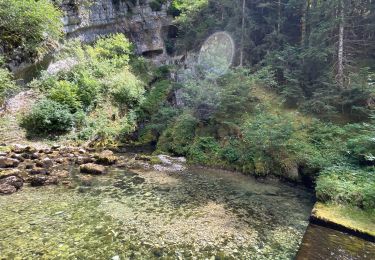
Se garer en bas du sentier d'interprétation de la Langouette. Quitter le parking au poteau "le martinet" et traverser le pont. Monter l'escalier à gauche et suivre le parcours aménagé le long de la gorge. Rejoindre la D127.
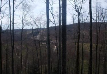
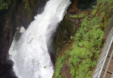
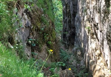
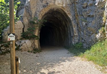
Tunnel entre viaduc des Douanets et cascade du Bief de la Ruine
Localisation
Commentaires
Randonnées à proximité
![Randonnée Marche Les Planches-en-Montagne - Gorges de la Saine - Les Planches en Montagne - Photo](https://media.geolcdn.com/t/375/260/ext.jpg?maxdim=2&url=https%3A%2F%2Fservices.sitytrail.com%2FGeolivesWS%2FDownloadMedia.ashx%3FTrailID%3D317645%26Media%3D16918_6.jpg)
![Marche Marche](https://static1.geolcdn.com/sitytour/trail-icons/101.png)
Marche
![](/images/other/stat-length.png)
![](https://static1.geolcdn.com/siteimages/upload/files/16400158638029165_repeat_loop_refresh_sync_direction_icon.png)
![Randonnée Marche Les Planches-en-Montagne - à la découverte de la languette - Photo](https://media.geolcdn.com/t/375/260/ext.jpg?maxdim=2&url=https%3A%2F%2Fservices.sitytrail.com%2FGeolivesWS%2FDownloadMedia.ashx%3FTrailID%3D200298%26Media%3D20130624123522.jpg)
![Marche Marche](https://static1.geolcdn.com/sitytour/trail-icons/101.png)
Marche
![](/images/other/stat-length.png)
![](https://static1.geolcdn.com/siteimages/upload/files/16400158638029165_repeat_loop_refresh_sync_direction_icon.png)
![Randonnée Marche Les Planches-en-Montagne - Gorges Langouette et Malvaux 12.7.24 - Photo](https://media.geolcdn.com/t/375/260/5229ff7e-7e8e-4a2f-8edc-aba23199d13a.jpg&format=jpg&maxdim=2)
![Marche Marche](https://static1.geolcdn.com/sitytour/trail-icons/101.png)
Marche
![](/images/other/stat-length.png)
![](https://static1.geolcdn.com/siteimages/upload/files/16400158638029165_repeat_loop_refresh_sync_direction_icon.png)
![Randonnée Marche Les Planches-en-Montagne - Les Planches en Montagne Gorges de la Langouette - Photo](https://media.geolcdn.com/t/375/260/1f52f0ef-fc18-46a5-850c-a8206c37ca75.jpg&format=jpg&maxdim=2)
![Marche Marche](https://static1.geolcdn.com/sitytour/trail-icons/101.png)
Marche
![](/images/other/stat-length.png)
![](https://static1.geolcdn.com/siteimages/upload/files/16400158638029165_repeat_loop_refresh_sync_direction_icon.png)
![Randonnée Marche Foncine-le-Haut - Circuit Creux Maldru - Photo](https://media.geolcdn.com/t/375/260/c5572b14-7842-4c9a-a4fb-45327348d69a.jpg&format=jpg&maxdim=2)
![Marche Marche](https://static1.geolcdn.com/sitytour/trail-icons/101.png)
Marche
![](/images/other/stat-length.png)
![](https://static1.geolcdn.com/siteimages/upload/files/16400158638029165_repeat_loop_refresh_sync_direction_icon.png)
![Randonnée V.T.T. Foncine-le-Haut - Jura 2 - Photo](https://media.geolcdn.com/t/375/260/8eab54f3-443c-4436-ad02-6f2dcf41b1ff.jpg&format=jpg&maxdim=2)
![V.T.T. V.T.T.](https://static1.geolcdn.com/sitytour/trail-icons/202.png)
V.T.T.
![](/images/other/stat-length.png)
![](https://static1.geolcdn.com/siteimages/upload/files/16400158638029165_repeat_loop_refresh_sync_direction_icon.png)
![Randonnée V.T.T. Foncine-le-Haut - Jura 1 - Photo](https://media.geolcdn.com/t/375/260/eb748db3-1e12-4544-bd9f-6a30da2eb7e1.jpg&format=jpg&maxdim=2)
![V.T.T. V.T.T.](https://static1.geolcdn.com/sitytour/trail-icons/202.png)
V.T.T.
![](/images/other/stat-length.png)
![](https://static1.geolcdn.com/siteimages/upload/files/16400158638029165_repeat_loop_refresh_sync_direction_icon.png)
![Randonnée Marche Les Planches-en-Montagne - la languette - Photo](https://media.geolcdn.com/t/375/260/d7f09bac-b1c2-40d4-8f82-eb3ef82a986e.jpg&format=jpg&maxdim=2)
![Marche Marche](https://static1.geolcdn.com/sitytour/trail-icons/101.png)
Marche
![](/images/other/stat-length.png)
![](https://static1.geolcdn.com/siteimages/upload/files/16400158638029165_repeat_loop_refresh_sync_direction_icon.png)
![Randonnée Marche Foncine-le-Bas - Foncines-le-Bas, du viaduc des Douanets à la cascade du Bief de la Ruine. - Photo](https://media.geolcdn.com/t/375/260/606c1e83-67b7-4855-afa2-efec7122554e.jpg&format=jpg&maxdim=2)
![Marche Marche](https://static1.geolcdn.com/sitytour/trail-icons/101.png)
Marche
![](/images/other/stat-length.png)
![](https://static1.geolcdn.com/siteimages/upload/files/16400158638029165_repeat_loop_refresh_sync_direction_icon.png)
très bien
super